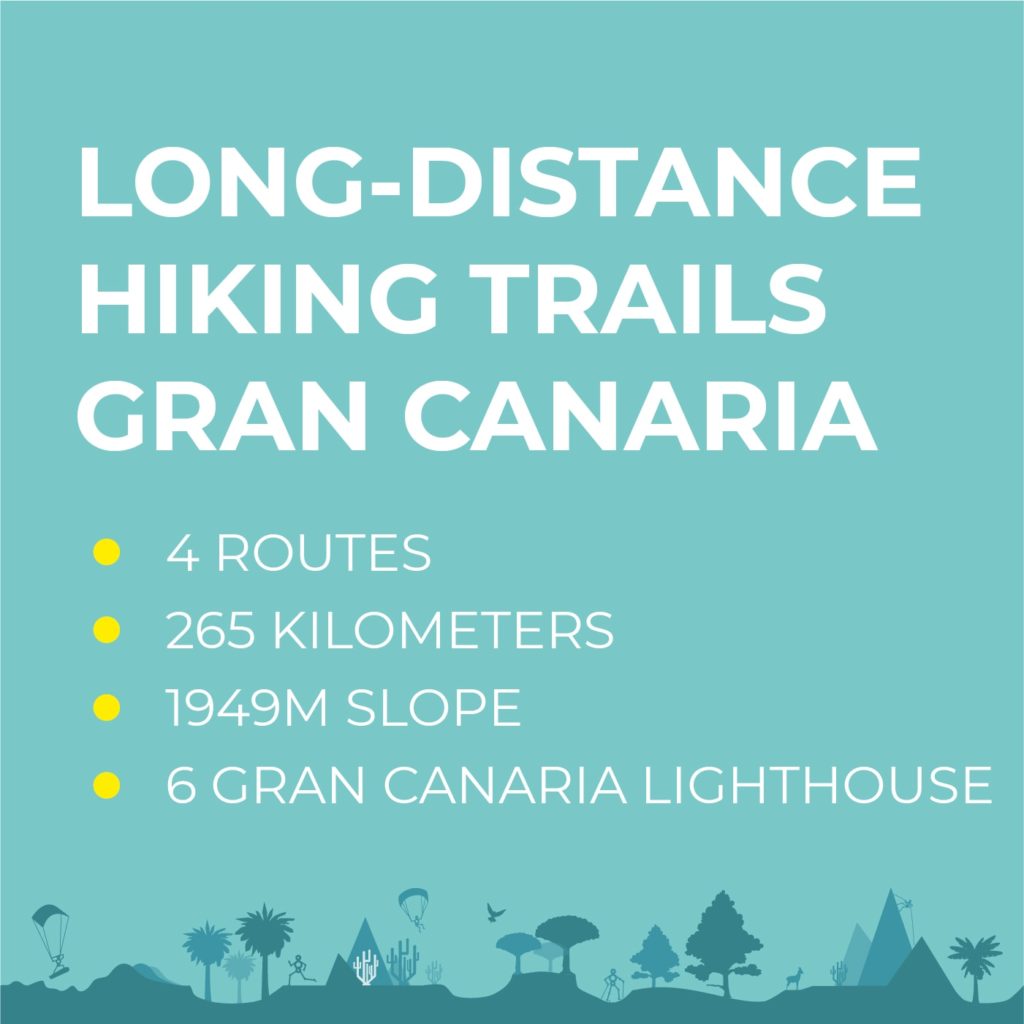
4 LONG DISTANCE HIKING TRAILS IN GRAN CANARIA
What if we cross the island of Gran Canaria on foot? This was what came to mind and now it has become a reality, touring the island of Gran Canaria through 4 transversal routes, linking the coast, the midlands and the highest point, the Cumbre de Gran Canaria.
This is how this project began, with one goal, with a great team and with a lot of desire to discover Gran Canaria on foot, to know its mountains, its coast, its hidden places, its people, its towns, its traditions to show this incredible island to everyone the world.
This dream and the common project started from a deep desire to explore Gran Canaria with the great challenge of doing it, neither more nor less than on foot, connecting with the only 6 lighthouses on the entire island.
We wanted to live this adventure, which was not easy at all, to investigate, explore, and know the nature surrounding us better, with an honest and natural look at the island of Gran Canaria and its spectacular trails.
You can find out about our adventure, check each route’s stages that was carried out on this page, or visit our Instagram profile.
We invite you to join us in this adventure on this page or Instagram. In addition, we are going to track every point of the way, because we are sure that, sooner or later, you will also want to do this journey on foot through Gran Canaria.
And if you want to follow our steps, you can see the tracking of the entire route at this link:
ROUTE 1: ARUCAS – SAN BARTOLOMÉ DE TIRJANA
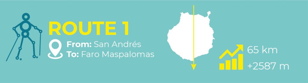
STAGE 1: SAN ANDRÉS – CRUZ DE TEJEDA
24,3 km, +1942 m elevation gain
The first stage of this project aims to highlight one of Gran Canaria’s greatest treasures, the Laurisilva Forest of the Doramas’ Reserve.
The route begins in the picturesque coastal village of San Andrés, a place that is beginning to develop its tourist centre around surfing, on a coastline full of secrets, natural pools, water caves and people whose lives are fully conditioned by the sea.
After a morning swim, we start our way through the Azuaje’s ravine, a place full of history and magic, we visit the abandoned Balnearium of the last century, an endemic and varied flora, known as the path of the thousand fountains. A unique route surrounded by water and vegetation.
We follow our path along the Barranco de Las Madres ravine, passing by Teresita’s shop, a traditional overseas shop. We climb the last stretch, the Barranco de La Vírgen, where the pines find refuge in the humidity of the north. We reach the Cruz de Tejeda, a place to regain our strength with good local products.
STAGE 2: CRUZ DE TEJEDA – MASPALOMAS LIGHTHOUSE
40,9 km, +631 m elevation gain
The second segment starts at Cruz de Tejeda and continues along the Camino de Santiago towards Tunte. In this first section we enjoy the incredible views of the Caldera de Tejeda, and later the Caldera de Tirajana. Passing near some dams and taking the Camino de La Plata, one of the first paths that linked the southern area with the centre of the island.
From the village of Tunte we go down to Fataga’s ravine, passing through the village and the incredible oasis formed by its palm grove, until we reach the sport climbing sector.
We continue along the course of the ravine and then pass the Necropolis of Arteara, where we make our last stop before arriving at the nature reserve of Las Dunas de Maspalomas.
The route ends at the Maspalomas Lighthouse with a nice swim at sunset.
ROUTE 2: LAS PALMAS DE GRAN CANARIA – MOGÁN
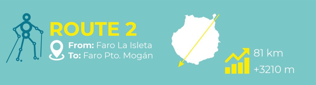
STAGE 1: LA ISLETA LIGHTHOUSE – PICO DE LAS NIEVES
Almost 40,4 km and +2216 m of elevation gain
The second route starts at one of the most northerly points on the island, the lighthouse of La Isleta, from where you can enjoy beautiful views of the city and the Confital Bay.
The route crosses the city along the maritime avenue until we reach the historic centre of the city, where we make a stop before beginning the ascent through the Guiniguada’s ravine.
Gradually, we will ascend passing through the Canarian Garden and continue along this leafy ravine, enjoying the endemic flora until we reach the villages of Santa Brigida and San Mateo. We will take the road to Siete Fuentes and reach the summit of the island, where an enormous surprise was waiting for us.
To finish this phase we climbed to the summit of the island, Pico de Las Nieves, where the well-known mountaineer and high mountain guide, Javier Cruz, guided us on our ascent to Morro de la Agujereada, which is the highest point on the island.
STAGE 2: GARAÑÓN – MOGÁN LIGHTHOUSE
40,8 km and +994 m of elevation gain
Leaving Pico de Las Nieves, we started the second stage phase to Los Hornos dam and the Roque Nublo towards Las Niñas dam. After a majestic descent through El Aserrador and a previous visit to the Bentayga’s window, we arrived at Juncal de Tejeda, where we began our approach to the area of the dams through the Reserva Integral de Inagua.
Near the dams, Las Niñas, Soria, El Mulato and Salto de Perro, there are some cheese dairies where you can taste delicious local cheeses. If the weather is fine, we will take a refreshing swim in the dam, before continuing with some trail running towards the Tauro mountain. A unique place for the eyes, with steep slopes leading down to Mogán’s ravine.
The last part of the trail is a vertiginous descent towards Mogán’s port, with a view over the village, a place where some of our delicacies such as avocados and mangos are grown. And with the desire to regain our strength, our second route ended at the Mogán’s lighthouse.
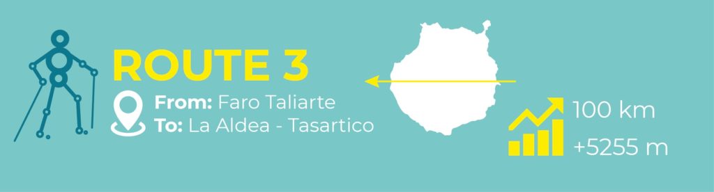
ROUTE 3: TALIARTE LIGHTHOUSE – LA ALDEA
STAGE 1: TALIARTE LIGHTHOUSE – TEJEDA
40 km and +2422 m of elevation gain
The third route starts at the lighthouse of Taliarte. From there we walk in towards the beautiful coastal village of Tufia, where we can have a swim and do a bit of snorkelling. We continued our way inland through the municipality of Agüimes, specifically through the Montaña de Pajonales, enjoying the immense views over the Barranco de Guayadeque.
After appreciating the views, we decided to descend to the ravine, again a descent of great height and beauty. Once inside the ravine, as a heat shelter and after a refreshing break in the local restaurant caves, we began the ascent to the summit via the Montaña de Las Tierras.
On this same ascent, once we had reached a significant height for the appearance of pine trees, we found ourselves in the Caldera de Los Marteles Reserve, a young volcanic cone, which allowed us to recuperate our breath and energy after this exhausting day of hiking.
STAGE 2: TEJEDA – LA ALDEA
43 km and +1800 m elevation gain
During the second stage, we went into the interior of the Caldera de Tejeda, passing through the village where we were able to enjoy the traditional almond desserts made in the traditional way to get energy and continue to the Roque Bentayga.
With incredible views of Roque Bentayga, we could feel our history, a feminine energy present in the matriarchy that lived there before the conquest. Leaving the Bentayga behind us and crossing the small villages of El Espinillo, La Solana, El Chorrillo and El Carrizal, we entered the solitude of this part of the island.
Near La Mesa del Juncalillo we come across several ravines that are completely uninhabited, where silence and solitude are the main characteristics. In search of the sea, along a path from which we can see the Vega de Acusa, La Aldea and even Tenerife, we enter the last ravine before reaching our final destination.
At the height of the Pino Gordo’s Ravine, Pablo Rada, a guide from the Climbo company, was waiting for us to carry out a canyoning activity in this same canyon. An activity full of emotion and freshness to finish in La Aldea de San Nicolás.
STAGE 3: LA ALDEA – GUGUY
17,5 km and +1033 m elevation gain
On the last day, quite tired and wishing to recover, we started our way to Guguy, a unique reserve, full of magic ravines and majestic mountains that protect one of the beaches to visit on our island. We reached the beach by the longest and most beautiful route, La Aldea, and then took the shortest and steepest route, Tasartico.
ROUTE 4: SANTA LUCÍA – AGAETE – GÁLDAR

STAGE 1: ARINAGA LIGHTHOUSE – TEJEDA
51 km, +2448 m of elevation gain
The last route starts at the lighthouse in the coastal village of Arinaga. After a refreshing morning swim, we start our way towards Pozo Izquierdo to watch the high-level sportsmen practicing kitesurfing, helped by the constant force of the wind that never stops blowing.
Once we had seen this, we entered the Tirajana’s ravine, which stands out for its reddish stone. Halfway through the ravine, we were able to visit La Fortaleza, one of the last strongholds of the Canarian aborigines. We continued through the ravine, passing the Tirajana Dam, the village of La Sorrueda, as well as the different climbing sectors until we reached El Ingenio de Santa Lucía, a village of great beauty that stands out for being located in an authentic oasis among palm trees.
The last part of the trail we did was with the sunset through the Montaña de Los Huesos with an incredible view over El Risco Blanco, to finally climb to the summit by the path known as the ascent of Betenjuí’s Route, a very technical climb with a steep slope. From here we walk the last stretch to spend the night in Andén del Toro.
STAGE 2: TEJEDA – PUERTO DE LAS NIEVES
28,9 km, +758 m of elevation gain
The second last stage of this project descends from the summit to the paradisiacal north coast. Starting from Andén del Toro, we arrive early in the morning in the village of Artenara and then enter the Natural Park of Tamadaba. We walk through pine trees to take the road to San Pedro and the best place to get to know the tradition of La Rama. Again a steep descent to reach the Valle de Agaete, where you can visit the Bodega Los Berrazales and taste its wines and cheeses.
To finish this stage we arrive at Puerto de Las Nieves, where we are welcomed by the Cordial Roca Negra de Agaete for a perfect night rest before the last day of the route.
STAGE 3: PUERTO DE LAS NIEVES – SARDINA LIGHTHOUSE
7,7 km, +400 m of elevation gain
The last section of our route was much shorter than the previous ones, as we walked from Agaete to the Sardina’s del Norte lighthouse.
On the way, we were able to visit several bays in the north, as well as Playa del Juncal or Playa del Lagarto, until we reached our last lighthouse, a place full of pools and marine fauna, El Faro de Sardina, a magical place where Edward Fox was waiting for us with his band to make us fall in love with his music in a unique sunset.
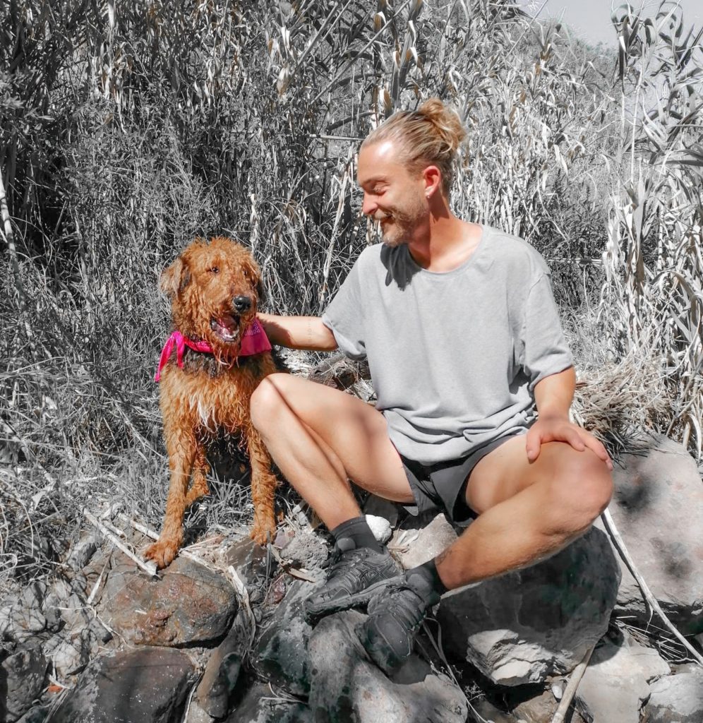
The man and the dog
Do you know Lucas Myon?
Hello! I am Lucas Myon and I am always accompanied by my dog Gofio. I am half French, half Canarian since I was born in 1993 in Nice (France), but I have been in Gran Canaria since I was 3 years old, every day more in love with this place.
I have a degree in Economics from the University of Las Palmas de G.C. Also, I have a pre-doctoral Master’s Degree in Economic Research from the Autonomous University of Barcelona and a Master’s Degree in International Banking and Finance that I did in Hong Kong.
Currently, I work with Climbo as a guide for the tours we do in Gran Canaria and I am preparing the Tourist Guide training.
You may wonder why I am telling you all this, but it has a reason, I want to explain to you why this project of the crossing on foot in Gran Canaria is so personal and means so much to me. Despite having studies and
The reason for this project has a personal origin, it is a change in life perspective since after years immersed in an economic and business sector, I decided to take a 180º turn and turn my love for nature into my way of life. In my appreciation and admiration for the spectacular nature that Gran Canaria has and the desire to show the world the hidden treasures of this island, the idea arose of making a journey on foot, from end to end of Gran Canaria, through 4 routes transversal and connect with the different geographical areas: the coast, the medianía, and La Cumbre de Gran Canaria, passing through the only 6 lighthouses in Gran Canaria.
Dreams sometimes come true
During this super adventure on foot in Gran Canaria, my dog Gofio will accompany me, he is 10 months old and is the best companion you can have, he is quiet, has a lot of energy, and is always ready to explore the most remote corners.
Besides, translating this dream into reality has been possible thanks to the collaboration of CLIMBO, which has the same spirit of exploring the island and being able to show it to everyone.
FOLLOW US ON INSTAGRAM

Climbo Staff
And we are Climbo
Hello! We are CLIMBO and we are an adventure sports and activities company. Maybe you already know us, but we are passionate about climbing, the Via Ferrata, canyoning, and everything that has to do with adrenaline sports, fun, and of course, adventure. Also, we are lucky to be in Gran Canaria, a unique island with incredible nature to climb and to practice multiple adventure sports. Gran Canaria is not only beach and sun, but it also has fantastic magical places to discover, therefore, but our goal is also to help you get to know the island with our tours and activities.
Of course, we are going to accompany Lucas Myon and his dog, Gofio, throughout the tour, because the teams go to the end of the world.
SPONSOR
PARTNERS